Community protected areas
Published by: Open Development Cambodia
Data Resources (7)
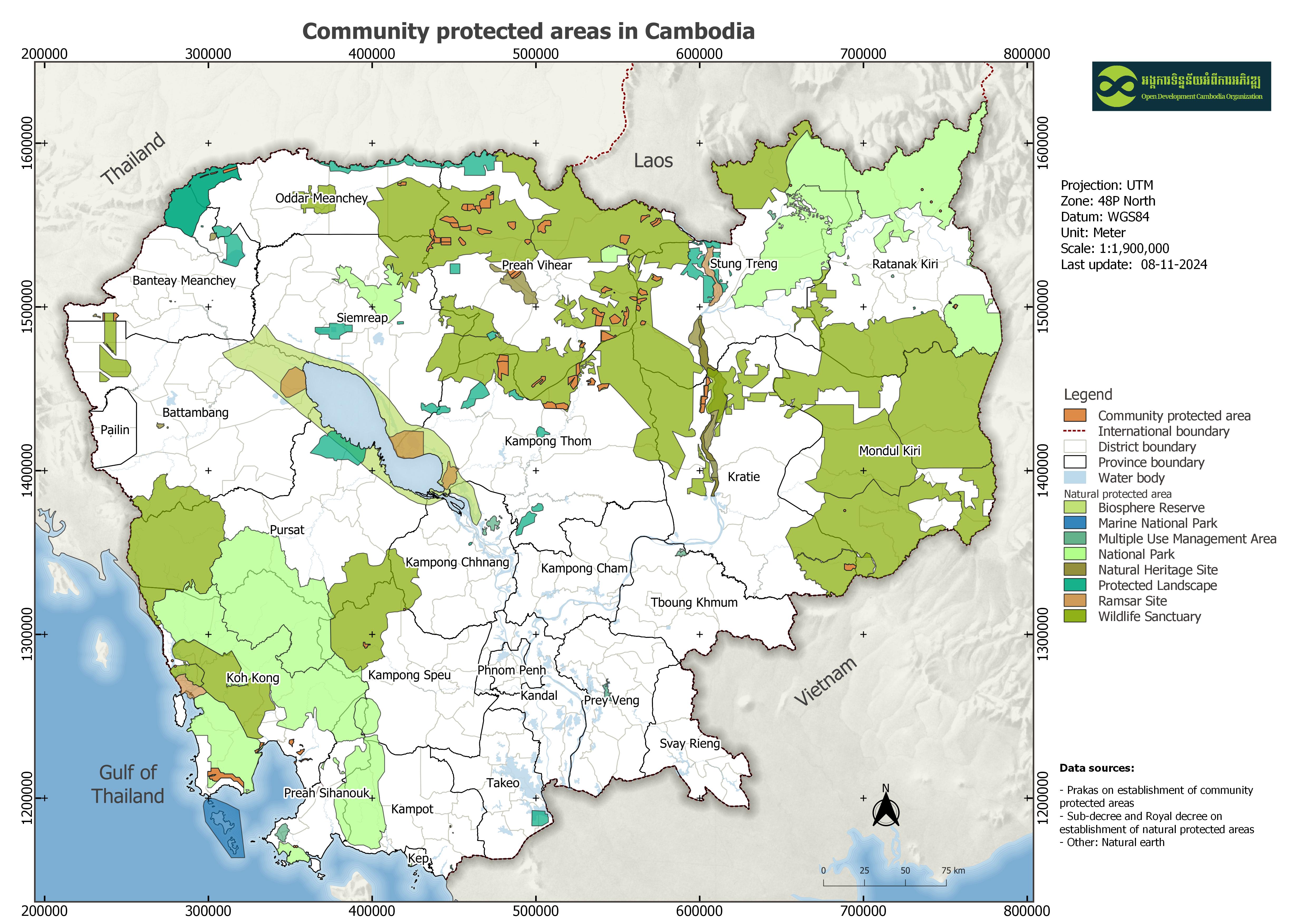
Data Resource Preview - Community protected areas
Additional Info
| Field | Value |
|---|---|
| အချက်အလက်အစု ခေါင်းစဉ်အမျိုးအစား |
|
| ဘာသာစကား |
|
| အသုံးပြုခြင်းဆိုင်ရာ အကန့်အသတ်များ | By accessing this website or database, users agree to take full responsibility for reliance on any site information provided and to hold harmless and waive any and all liability against individuals or entities associated with its development, form and content for any loss, harm or damage suffered as a result of its use. |
| အချက်အလက်အစုကို ရည်ညွှန်းသောရက်စွဲ | 2019၊ 2 ဧပြီ |
| ယာယီအတိုင်းအတာ၏ စတင်နေ့စွဲ | 2006၊ 21 ဇွန် |
| ယာယီအတိုင်းအတာ၏ ပြီးဆုံးနေ့စွဲ | 2020၊ 31 ဒီဇင်ဘာ |
| ဘူမိအမည်များ |
|
| သတ်မှတ်ဧရိယာ၏ အနောက်ဘက် ကိုဩဒိနိတ် | 102.54859870122804 |
| သတ်မှတ်ဧရိယာ၏ အရှေ့ဘက် ကိုဩဒိနိတ် | 107.38900215119163 |
| သတ်မှတ်ဧရိယာ၏ တောင်ဘက် ကိုဩဒိနိတ် | 10.496327885971324 |
| သတ်မှတ်ဧရိယာ၏ မြောက်ဘက် ကိုဩဒိနိတ် | 14.344214200747942 |
| နေရာဆိုင်ရာ ရည်ညွှန်းစနစ် | WGS 84 / UTM zone 48N (EPSG:32648) |
| အနေအထား တိကျမှန်ကန်မှု | The data is manually digitized from the scan documents. |
| ကျိုးကြောင်းဆီလျော်မှုရှိ၊ မရှိ | There is no logical consistency. |
| ပြည့်စုံမှု | This dataset contains all of the data that is currently available to Open Development Cambodia (ODC) and is not exhaustive. ODC takes every effort to ensure that the details in this map are accurate and up to date. |
| ဖြစ်စဉ် | The available data was collected by ODC from the government both in PDF and hardcopy format. The data format was scan and transformed to shapefile format by geo referencing, and digitizing. The data in shapefile format was finally exported to HTML, KML, and GEOJSON files. |
| ရင်းမြစ်များ | Royal Gazette from government of Cambodia, Sub-decree and Prakas, from 2006-2019 |
| တာဝန်ရှိသော အဖွဲ့အစည်း | Ministry of Environment Address: Morodok Techo building, Lot #503, Sangkat Tonlebasak, Khan Chomkarmon, Phnom Penh, Cambodia. Email: info@moe.gov.kh, Phone: (+855) 23 213 908, (+855) 23 220 369, Fax: 023 212 540 |
| Metadata ကို ဖန်တီးသူ၏ သတင်းအချက်အလက် | Metadata last updated on 2025-08-07. For inquiries contact: Open Development Cambodia, Email: contact@opendevcam.net, Website: http://www.opendevcam.net Address: 23B St.606, Phnom Penh, Cambodia |
| ၀ိသေသများ | name: community name; size_ha: size in hectare; npa_name: natural protected areas name; village:village name; commune: commune name; district: district name; province: province name; issued_dat: issued date; reference: referencing documents |
| ခွင့်ပြုချက် | Creative Commons Attribution |
| မူပိုင်ခွင့် | Yes |
| ပြင်ဆင်ချက် | 1.0 |
| အဓိကစကားလုံးများ | CPA,community protected areas |
| တင်ခဲ့သည့်ရက်စွဲ | ဇွန် 11, 2018, 09:41 (UTC) |
| ပြန်လည်ပြင်ဆင်သည့်ရက်စွဲ | ဧပြီ 20, 2026, 04:16 (UTC) |