| အချက်အလက်အစု ခေါင်းစဉ်အမျိုးအစား |
- Agriculture and fishing
- Crop products and commodities
- SDG15 Life on Land
|
| ဘာသာစကား |
|
| အသုံးပြုခြင်းဆိုင်ရာ အကန့်အသတ်များ |
By accessing this website or database, users agree to take full responsibility for reliance on any site information provided and to hold harmless and waive any and all liability against individuals or entities associated with its development, form and content for any loss, harm or damage suffered as a result of its use.
|
| အချက်အလက်အစုကို ရည်ညွှန်းသောရက်စွဲ |
2013၊ 4 ဩဂုတ်
|
| ဘူမိအမည်များ |
|
| သတ်မှတ်ဧရိယာ၏ အနောက်ဘက် ကိုဩဒိနိတ် |
102.324556627706 |
| သတ်မှတ်ဧရိယာ၏ အရှေ့ဘက် ကိုဩဒိနိတ် |
107.60658466965369 |
| သတ်မှတ်ဧရိယာ၏ တောင်ဘက် ကိုဩဒိနိတ် |
10.358216764769473 |
| သတ်မှတ်ဧရိယာ၏ မြောက်ဘက် ကိုဩဒိနိတ် |
14.69620254438913 |
| နေရာဆိုင်ရာ ရည်ညွှန်းစနစ် |
WGS 84 / UTM zone 48N (EPSG:32648) |
| အနေအထား တိကျမှန်ကန်မှု |
There are no known about the issues of accuracy.
|
| ကျိုးကြောင်းဆီလျော်မှုရှိ၊ မရှိ |
There are no known about the issues of logical consistency.
|
| ပြည့်စုံမှု |
Completeness according to data source from World Food Programme GeoNode (WFPGeoNode) using data from the Department of Land and Geography of the Ministry of Land Management, Urban Planning and Construction.
|
| ဖြစ်စဉ် |
This dataset was originally downloaded from the WFPGeoNode of Cambodia in SHP format then its projection was transformed to WGS84 Zone 48 N and converted to multiple file formats such as KML, GeoJSON, CSV and JPEG.
|
| ရင်းမြစ်များ |
Downloaded from WFPGeoNode: https://geonode.wfp.org/layers/geonode%3Akhm_phy_cropland_gov. Data Source: Department of Land and Geography of the Ministry of Land Management, Urban Planning and Construction
|
| တာဝန်ရှိသော အဖွဲ့အစည်း |
World Food Programme (WFP)
Address: House 108, Street 63, Sangkat Boeung Raing, Khan Daun Penh, Phnom Penh. Phone: (+855) 23 210943, Fax: (+855) 23 218749, Email: WFP.PhnomPenh@wfp.org
|
| Metadata ကို ဖန်တီးသူ၏ သတင်းအချက်အလက် |
Metadata last updated on 2019-08-02. For inquiries contact: Open Development Cambodia (ODC). Address: #43 St. 208, Phnom Penh, Cambodia. Email: contact@opendevcam.net Website: https://opendevelopmentcambodia.net
|
| ၀ိသေသများ |
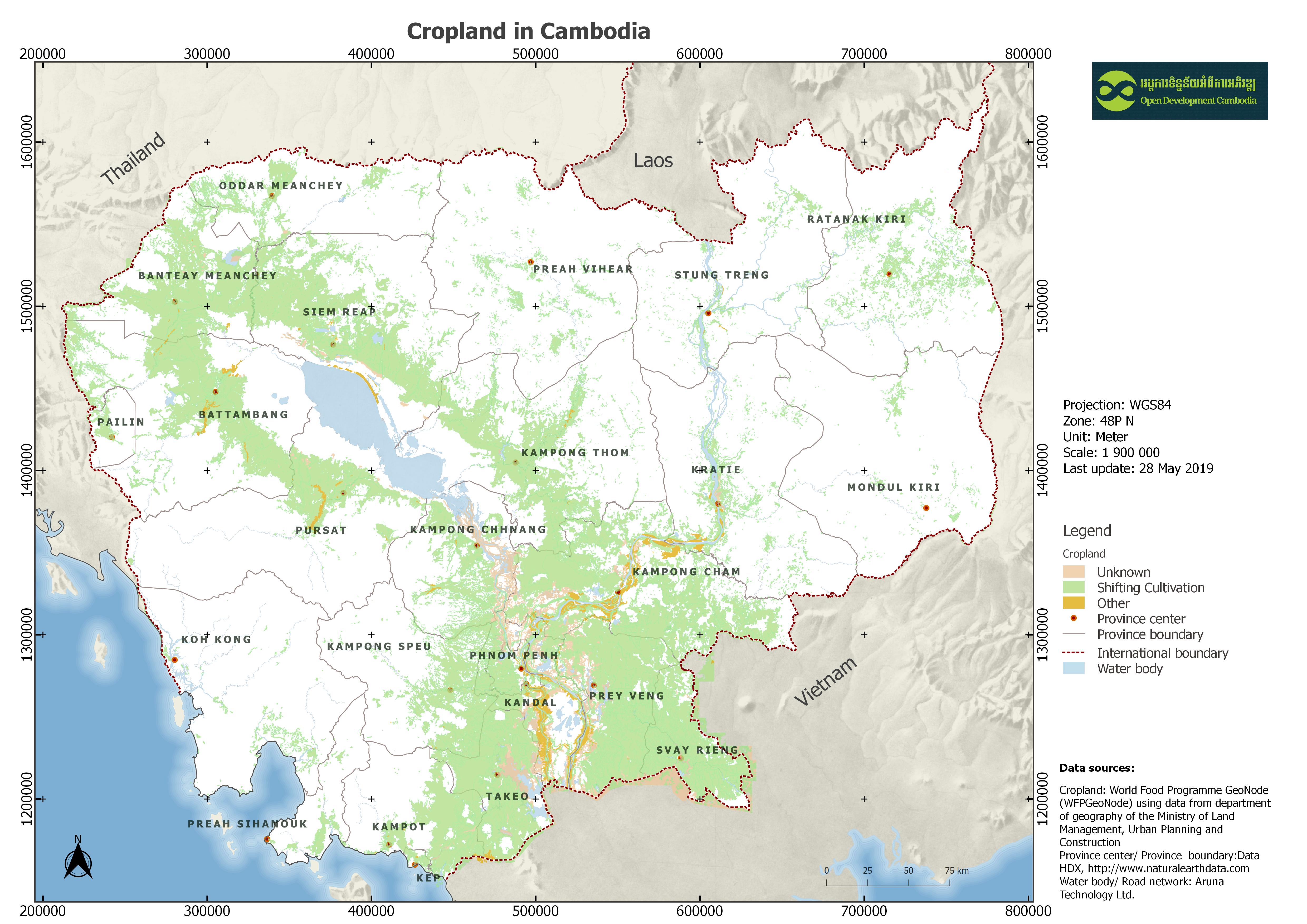
area: Area in sq. meter; name: Name used for Geography Department only; fcode: Type of feature layer; ftc: Farming Type Category (0 Unknown, 1 Shifting cultivation, 4 Other); veg: Vegetation Characteristics (0 Unknown, 4 Rice field, 21 Other)
|
| ခွင့်ပြုချက် |
CC-BY-SA-4.0
|
| မူပိုင်ခွင့် |
Yes |
| ပြင်ဆင်ချက် |
1.0 |
| အဓိကစကားလုံးများ |
cropland,crop,ដីដាំដំណាំក្នុងប្រទេសកម្ពុជា |
| တင်ခဲ့သည့်ရက်စွဲ |
ဩဂုတ် 2, 2019, 15:46 (UTC)
|
| ပြန်လည်ပြင်ဆင်သည့်ရက်စွဲ |
ဒီဇင်ဘာ 16, 2020, 10:35 (UTC)
|