Economic corridors of Cambodia
Published by: Open Development Cambodia
Data Resources (6)
Data Resource Preview - Economic corridors of Cambodia
Additional Info
| Field | Value |
|---|---|
| အချက်အလက်အစု ခေါင်းစဉ်အမျိုးအစား |
|
| ဘာသာစကား |
|
| အသုံးပြုခြင်းဆိုင်ရာ အကန့်အသတ်များ | No access and use constraints. |
| အချက်အလက်အစုကို ရည်ညွှန်းသောရက်စွဲ | 2012၊ 2 ဇန်နဝါရီ |
| ဘူမိအမည်များ |
|
| သတ်မှတ်ဧရိယာ၏ အနောက်ဘက် ကိုဩဒိနိတ် | 102.551300048828 |
| သတ်မှတ်ဧရိယာ၏ အရှေ့ဘက် ကိုဩဒိနိတ် | 107.504234313965 |
| သတ်မှတ်ဧရိယာ၏ တောင်ဘက် ကိုဩဒိနိတ် | 10.4262790679932 |
| သတ်မှတ်ဧရိယာ၏ မြောက်ဘက် ကိုဩဒိနိတ် | 13.9100093841553 |
| နေရာဆိုင်ရာ ရည်ညွှန်းစနစ် | WGS 84 (EPSG:4326) (CRS:84) |
| အနေအထား တိကျမှန်ကန်မှု | |
| ကျိုးကြောင်းဆီလျော်မှုရှိ၊ မရှိ | |
| ပြည့်စုံမှု | |
| ဖြစ်စဉ် | The data was visualized in CartoDB and created a custom legend and information windows for data points. Subsets of this data were created for presentation at country level. |
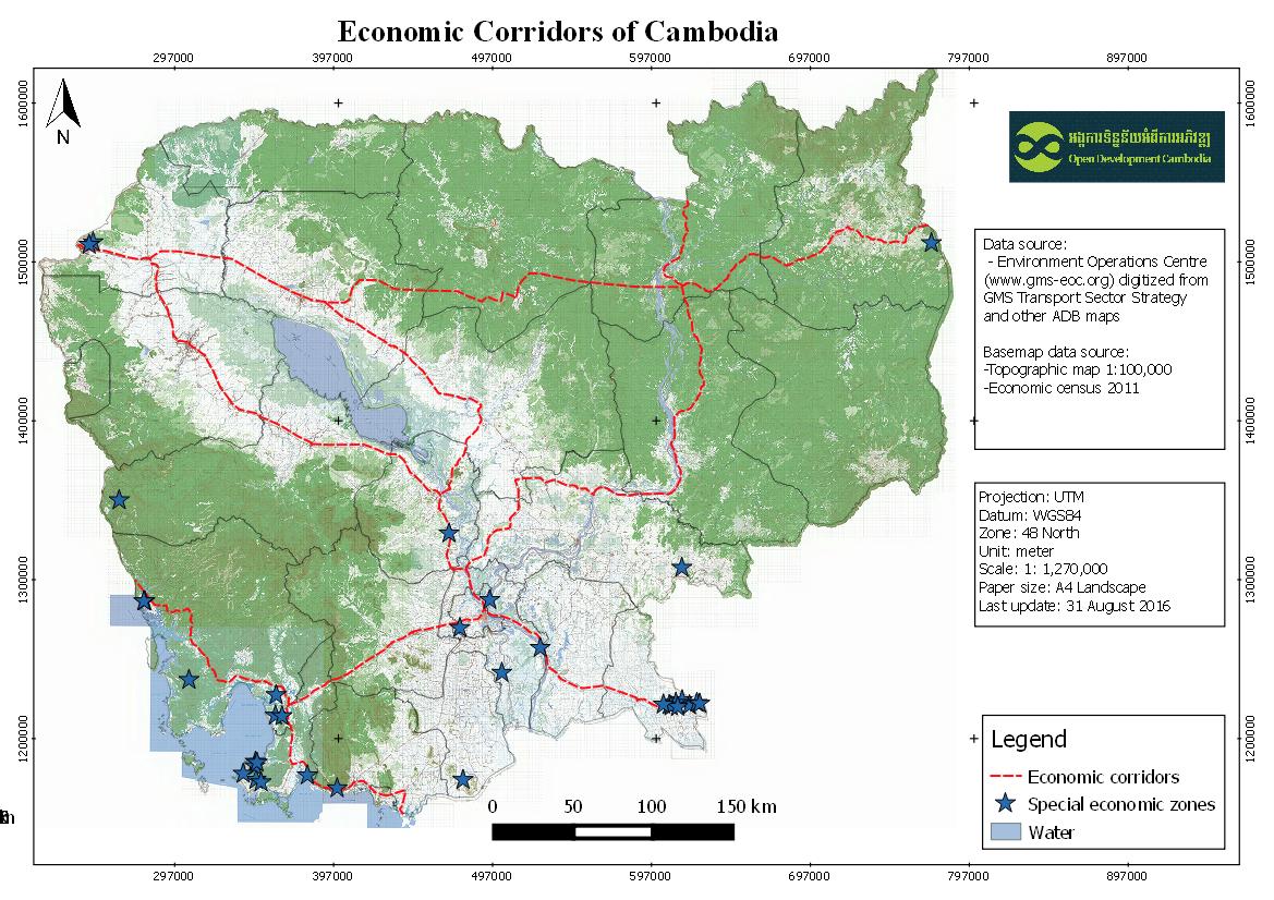
| ရင်းမြစ်များ | Environment Operations Centre (www.gms-eoc.org) digitized from GMS Transport Sector Strategy and other ADB maps. |
| တာဝန်ရှိသော အဖွဲ့အစည်း | |
| Metadata ကို ဖန်တီးသူ၏ သတင်းအချက်အလက် | Metadata last updated on 2016-05-31. For inquiries contact: Open Development Cambodia Address: #43 St. 208, Phnom Penh, Cambodia. Email: contact@opendevcam.net Website: http://www.opendevcam.net |
| ၀ိသေသများ | |
| ခွင့်ပြုချက် | unspecified |
| မူပိုင်ခွင့် | Unclear copyright |
| ပြင်ဆင်ချက် | 1.0 |
| တင်ခဲ့သည့်ရက်စွဲ | ဇူလိုင် 14, 2015, 10:34 (UTC) |
| ပြန်လည်ပြင်ဆင်သည့်ရက်စွဲ | အောက်တိုဘာ 8, 2019, 16:25 (UTC) |