Land cover in Cambodia (2012- 2016)
Published by: Open Development Cambodia
Data Resources (15)
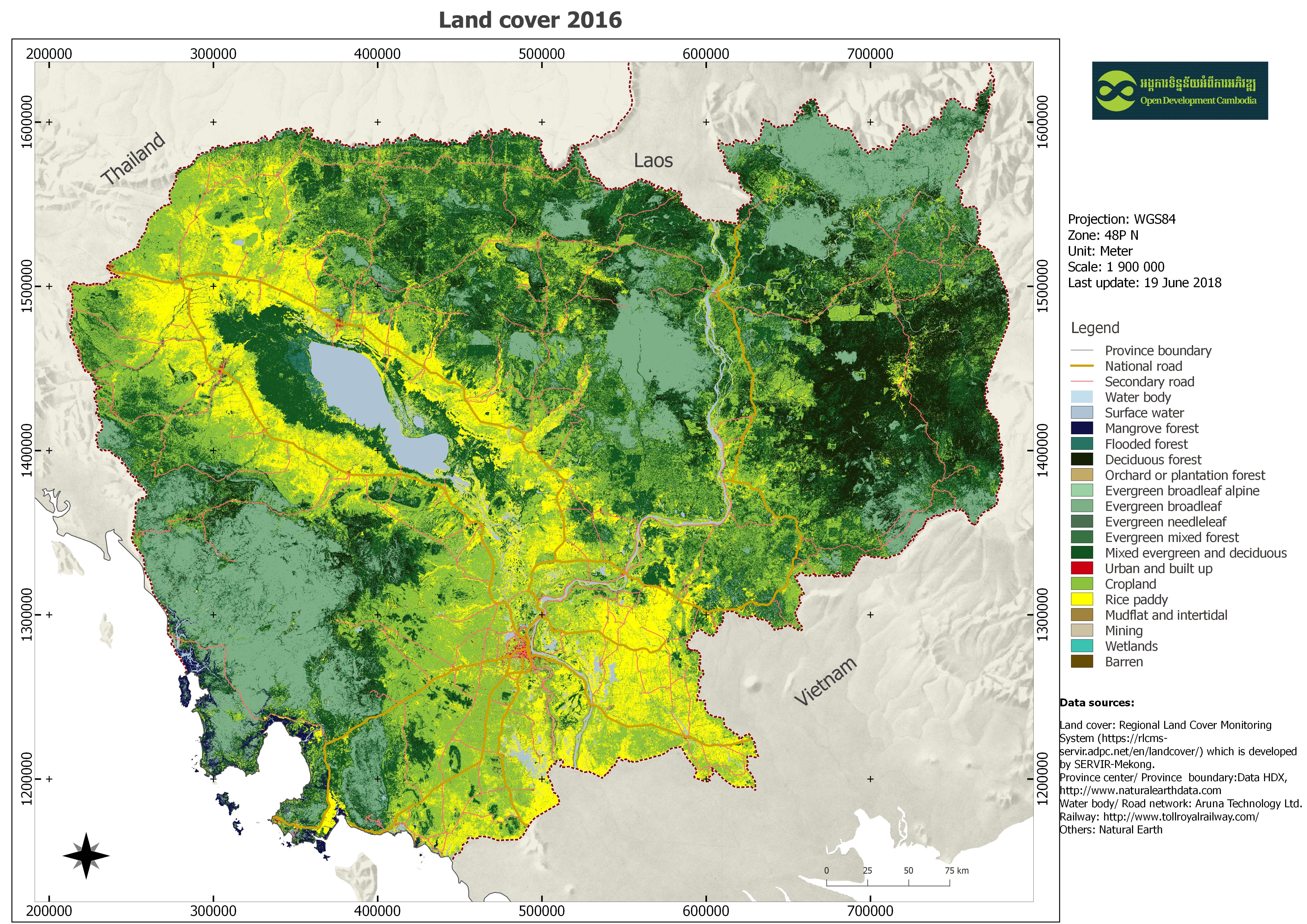
Data Resource Preview - Land cover in Cambodia 2016
Additional Info
| Field | Value |
|---|---|
| အချက်အလက်အစု ခေါင်းစဉ်အမျိုးအစား |
|
| ဘာသာစကား |
|
| အသုံးပြုခြင်းဆိုင်ရာ အကန့်အသတ်များ | By accessing this website or database, users agree to take full responsibility for reliance on any site information provided and to hold harmless and waive any and all liability against individuals or entities associated with its development, form and content for any loss, harm or damage suffered as a result of its use. |
| အချက်အလက်အစုကို ရည်ညွှန်းသောရက်စွဲ | 2018၊ 27 ဇွန် |
| ဘူမိအမည်များ |
|
| သတ်မှတ်ဧရိယာ၏ အနောက်ဘက် ကိုဩဒိနိတ် | 102.28887090812567 |
| သတ်မှတ်ဧရိယာ၏ အရှေ့ဘက် ကိုဩဒိနိတ် | 107.67199154675097 |
| သတ်မှတ်ဧရိယာ၏ တောင်ဘက် ကိုဩဒိနိတ် | 10.342608375726025 |
| သတ်မှတ်ဧရိယာ၏ မြောက်ဘက် ကိုဩဒိနိတ် | 14.705594299645867 |
| နေရာဆိုင်ရာ ရည်ညွှန်းစနစ် | WGS 84 / UTM zone 48N (EPSG:32648) |
| အနေအထား တိကျမှန်ကန်မှု | Land cover 2016 is the preliminary result. |
| ကျိုးကြောင်းဆီလျော်မှုရှိ၊ မရှိ | There is no issue related to logical consistency. |
| ပြည့်စုံမှု | This dataset is completed with the national wide. |
| ဖြစ်စဉ် | The data on land cover was extracted from the Regional Land Cover Monitoring System web-based application by administrative province of Cambodia. Then ODC team merged and masked the image for Cambodia map. |
| ရင်းမြစ်များ | Regional Land Cover Monitoring System (https://rlcms-servir.adpc.net/en/landcover/) developed by SERVIR-Mekong. |
| တာဝန်ရှိသော အဖွဲ့အစည်း | Asian Disaster Preparedness Center (ADPC) Address: SM Tower, 24th Floor, 979/69 Paholyothin Road, Samsen Nai Phayathai, Bangkok 10400 Thailand. Tel:+66 2 298 0681-92, Fax:+66 2 298 0012, Email: adpc@adpc.net, Website: https://www.adpc.net/igo/? |
| Metadata ကို ဖန်တီးသူ၏ သတင်းအချက်အလက် | Metadata last updated on 2018-06-27. For inquiries contact: Open Development Cambodia, Email: contact@opendevcam.net, Website: http://www.opendevcam.net Address: #43, St. 208, Phnom Penh, Cambodia. |
| ခွင့်ပြုချက် | unspecified |
| မူပိုင်ခွင့် | Unclear copyright |
| ပြင်ဆင်ချက် | 1.0 |
| အဓိကစကားလုံးများ | land use |
| တင်ခဲ့သည့်ရက်စွဲ | ဇွန် 27, 2018, 04:24 (UTC) |
| ပြန်လည်ပြင်ဆင်သည့်ရက်စွဲ | ဒီဇင်ဘာ 15, 2020, 08:20 (UTC) |