State land reclassification
Published by: Open Development Cambodia
Data Resources (7)
Data Resource Preview - State land reclassification
Additional Info
| Field | Value |
|---|---|
| အချက်အလက်အစု ခေါင်းစဉ်အမျိုးအစား |
|
| ဘာသာစကား |
|
| အသုံးပြုခြင်းဆိုင်ရာ အကန့်အသတ်များ | By accessing this website or database, users agree to take full responsibility for reliance on any site information provided and to hold harmless and waive any and all liability against individuals or entities associated with its development, form and content for any loss, harm or damage suffered as a result of its use. |
| ဘူမိအမည်များ |
|
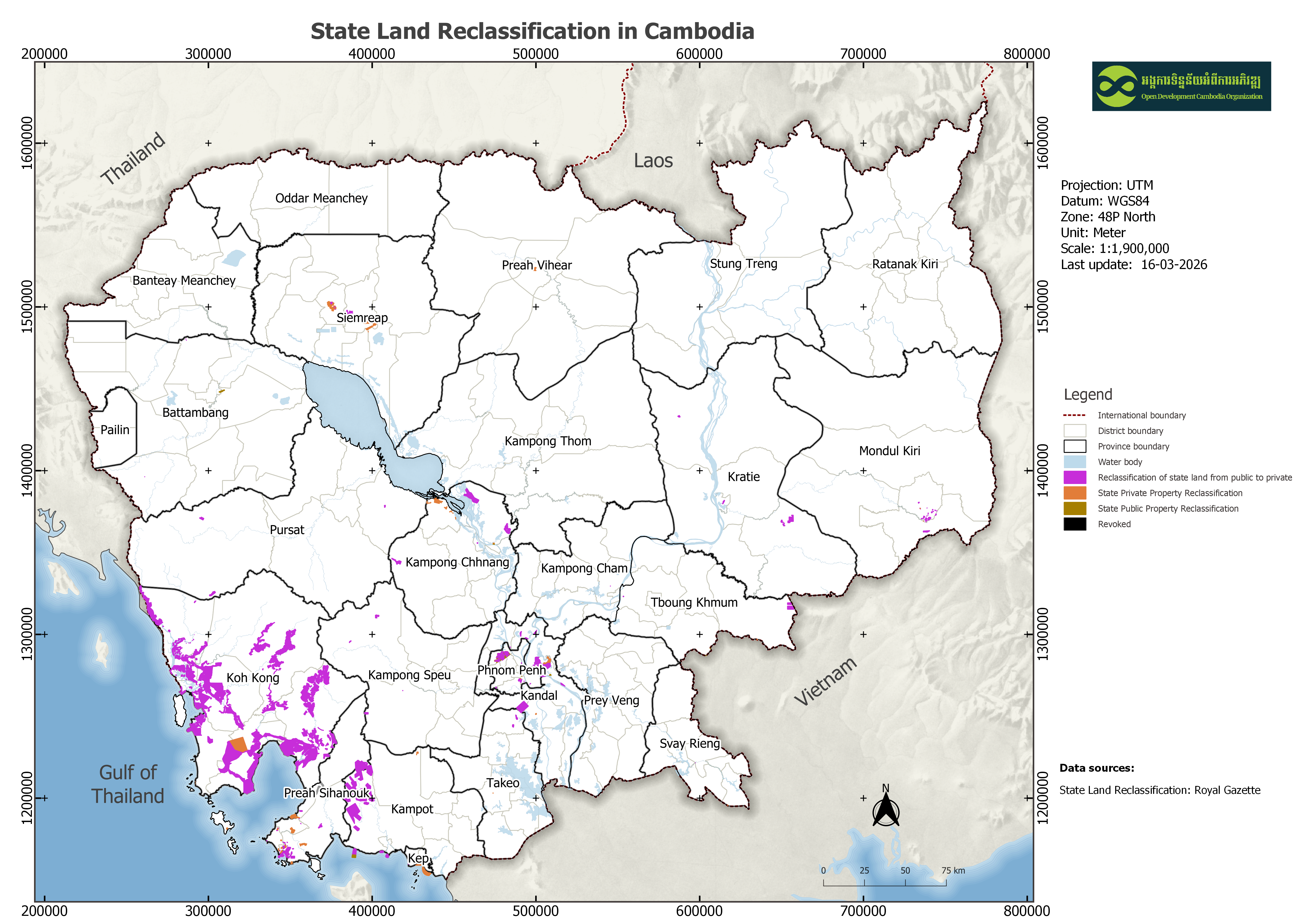
| သတ်မှတ်ဧရိယာ၏ အနောက်ဘက် ကိုဩဒိနိတ် | 103.60572241722225 |
| သတ်မှတ်ဧရိယာ၏ အရှေ့ဘက် ကိုဩဒိနိတ် | 105.08582199660128 |
| သတ်မှတ်ဧရိယာ၏ တောင်ဘက် ကိုဩဒိနိတ် | 10.539823299357336 |
| သတ်မှတ်ဧရိယာ၏ မြောက်ဘက် ကိုဩဒိနိတ် | 11.666236964364654 |
| နေရာဆိုင်ရာ ရည်ညွှန်းစနစ် | WGS 84 / UTM zone 48N (EPSG:32648) |
| အနေအထား တိကျမှန်ကန်မှု | Since the dataset was collected mostly through digitization of the scanned maps in the law document, there will inevitably be a few trivial spatial errors. |
| ဝိသေသဆိုင်ရာ တိကျမှန်ကန်မှု | The accuracy depends on the source of the Royal Gazette of Cambodia. |
| ကျိုးကြောင်းဆီလျော်မှုရှိ၊ မရှိ | There is no known about the issues of consistency. |
| ပြည့်စုံမှု | Completeness depends on the references that can be found by ODC's map experts, so this dataset requires further updating and monitoring. |
| ဖြစ်စဉ် | This dataset is acquired by converting the scanned map to SHP format through a process done using GIS tools such as point coordinate input, georeference, and digitization. |
| ရင်းမြစ်များ | Royal Gazettes of Cambodia |
| တာဝန်ရှိသော အဖွဲ့အစည်း | General Department of Royal Gazettes, Office of the Council of Ministers (OCM) Address: OCM, Friendship Building, 41 Russian Federation Blvd, Phnom Penh, Cambodia. Contact: Phone/Fax: (855) 23 212 490, E-Mail: info@pressocm.gov.kh, pressocm@gmail.com |
| Metadata ကို ဖန်တီးသူ၏ သတင်းအချက်အလက် | Metadata last updated on 2024-02-014. For inquiries contact: Open Development Cambodia, Email: contact@opendevcam.net, Website: http://www.opendevcam.net Address: 23B St. 606, Phnom Penh, Cambodia. |
| ၀ိသေသများ | map_id: ID number to identify map, name: Area/Grantee name, category: Category of property statement , owner: Grantee who has the privilege, area (ha): area in hectare unit, village: village name, commune: commune name, district: District name: province: Province name; references: References of the dataset |
| ခွင့်ပြုချက် | Creative Commons Attribution Share-Alike |
| မူပိုင်ခွင့် | Yes |
| ပြင်ဆင်ချက် | 1.0 |
| နယ်ပယ် |
|
| အဓိကစကားလုံးများ | state public property,state private propetry,land classification |
| တင်ခဲ့သည့်ရက်စွဲ | နိုဝင်ဘာ 15, 2019, 03:08 (UTC) |
| ပြန်လည်ပြင်ဆင်သည့်ရက်စွဲ | မတ် 16, 2026, 07:40 (UTC) |