| အချက်အလက်အစု ခေါင်းစဉ်အမျိုးအစား |
- Rural sanitation
- Urban sanitation infrastructure
- Water and sanitation
|
| ဘာသာစကား |
|
| အသုံးပြုခြင်းဆိုင်ရာ အကန့်အသတ်များ |
By accessing this website or database, users agree to take full responsibility for reliance on any site information provided and to hold harmless and waive any and all liability against individuals or entities associated with its development, form and content for any loss, harm or damage suffered as a result of its use.
|
| အချက်အလက်အစုကို ရည်ညွှန်းသောရက်စွဲ |
2011၊ 3 ဇန်နဝါရီ
|
| ဘူမိအမည်များ |
|
| သတ်မှတ်ဧရိယာ၏ အနောက်ဘက် ကိုဩဒိနိတ် |
96.42279972267175 |
| သတ်မှတ်ဧရိယာ၏ အရှေ့ဘက် ကိုဩဒိနိတ် |
112.90414924612124 |
| သတ်မှတ်ဧရိယာ၏ တောင်ဘက် ကိုဩဒိနိတ် |
-90.0 |
| သတ်မှတ်ဧရိယာ၏ မြောက်ဘက် ကိုဩဒိနိတ် |
14.421088144519471 |
| နေရာဆိုင်ရာ ရည်ညွှန်းစနစ် |
WGS 84 / UTM zone 48N (EPSG:32648) |
| အနေအထား တိကျမှန်ကန်မှု |
The Commune Database is comprised of self-reported data from each locality and has known inconsistencies in comparison to other sources, such as the census produced by the National Institute of Statistics.
|
| ကျိုးကြောင်းဆီလျော်မှုရှိ၊ မရှိ |
There are no known issues with logical consistency.
|
| ပြည့်စုံမှု |
ODC does not provide access to the full Commune Database since it is not already publicly available and ODC's information from the database is incomplete.
|
| ဖြစ်စဉ် |
Data were provided to Open Development Cambodia directly by Save Cambodia's Wildlife's 2013 Atlas Working Group in ESRI Shapefile format. Commune-level data were combined and exported in CSV, KML, and GeoJSON format.
|
| ရင်းမြစ်များ |
National Committee for Sub-National Democratic Development, Royal Government of Cambodia. Commune Database 2011. Phnom Penh, 2011. Save Cambodia's Wildlife. "Agriculture." Atlas of Cambodia: maps on socio-economic development and environment. Second ed. Phnom Penh, 2014. 135, 141-145. Print. Save Cambodia's Wildlife. "Gender." Atlas of Cambodia: maps on socio-economic development and environment. Second ed. Phnom Penh, 2014. 115. Print. Save Cambodia's Wildlife. "Energy." Atlas of Cambodia: maps on socio-economic development and environment. Second ed. Phnom Penh, 2014. 165. Print.
|
| တာဝန်ရှိသော အဖွဲ့အစည်း |
National Committee for Subnational Democratic Development info@ncdd.gov.kh +855 23 720 038 / 720 061 http://www.ncdd.gov.kh/en/ Save Cambodia's Wildlife (SCW) info@cambodiaswildlife.org +855 23 88 20 35 http://cambodiaswildlife.org 6Eo St.570, Sangkat Boeung Kak 2, Khan Tuol Kork, Phnom Penh, Cambodia
|
| Metadata ကို ဖန်တီးသူ၏ သတင်းအချက်အလက် |
Open Development Cambodia contact@opendevcam.net +855 23 221 164 http://www.opendevelopmentcambodia.net 43 St. 208, Sangkat Boeung Riang, Khan Daun Penh, Phnom Penh, Cambodia.
|
| ၀ိသေသများ |
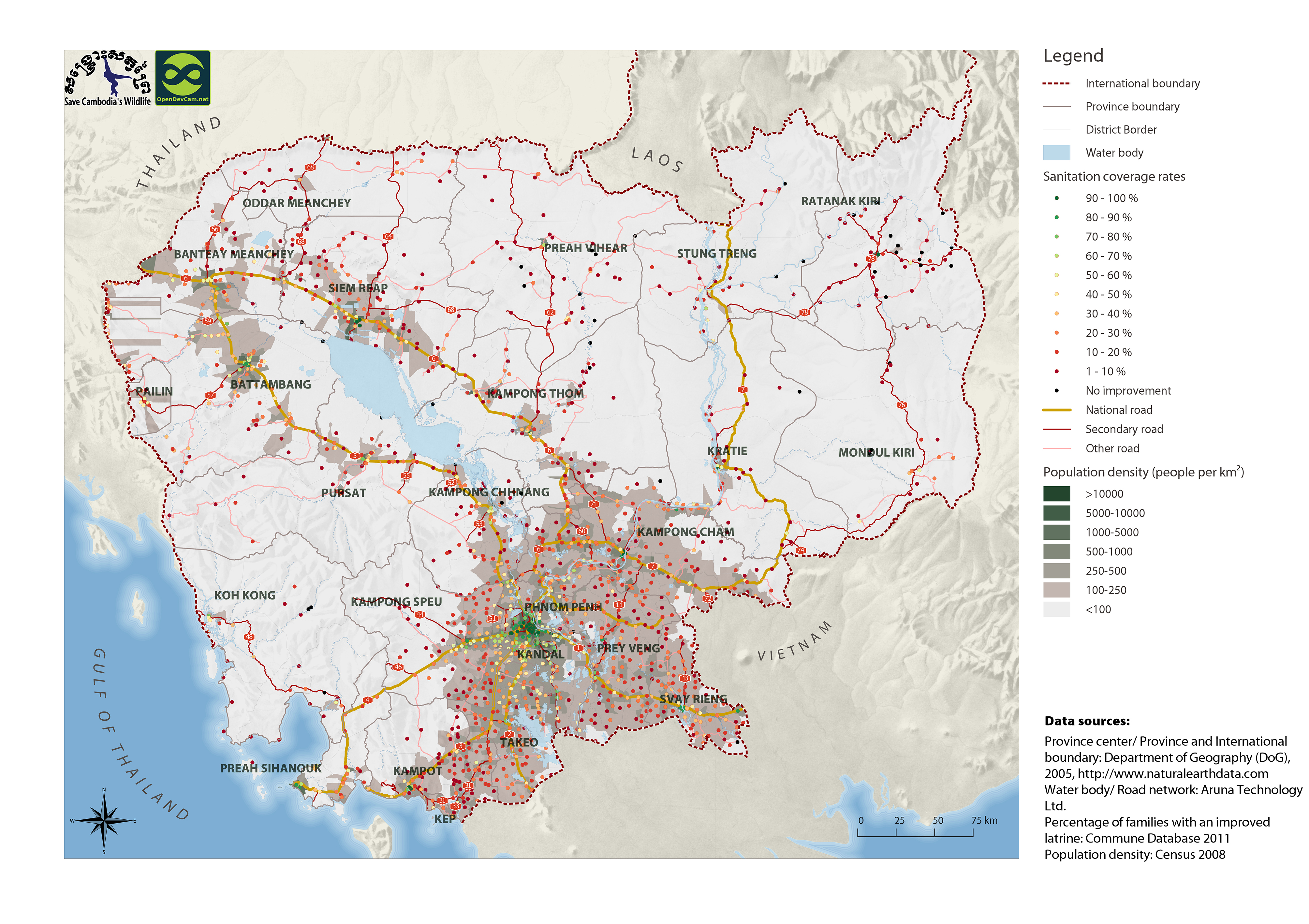
Fami_Impro / NCDD : number of families with improved latrines Fami_Unim / NCDD : number of families with unimproved latrines RatImpLatH / NCDD : ratio of improved latrines to households
|
| ခွင့်ပြုချက် |
CC-BY-4.0
|
| မူပိုင်ခွင့် |
No |
| ပြင်ဆင်ချက် |
1.0 |
| တင်ခဲ့သည့်ရက်စွဲ |
ဒီဇင်ဘာ 4, 2015, 20:06 (UTC)
|
| ပြန်လည်ပြင်ဆင်သည့်ရက်စွဲ |
အောက်တိုဘာ 8, 2019, 18:42 (UTC)
|